| ONE | TWO |
 |
 |
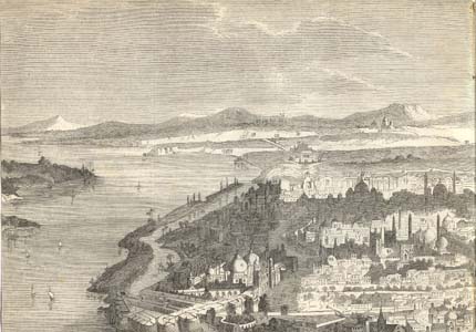
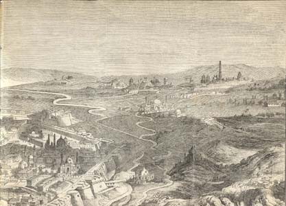
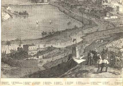
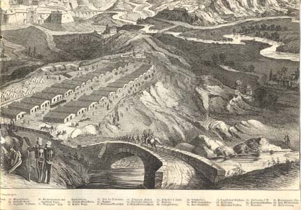
DELHI FROM THE RIDGE CAMP, 1857
| ONE | TWO |
 |
 |
 |
 |
| THREE | FOUR |
A view from the Illustrirte Zeitung, 14 Nov. 1857; CLICK ON ANY QUARTER
OF THE MAP FOR A VERY LARGE SCAN. Note: the ridge camp is to the northwest
of the city, so the angle of view is southward.
| *SECTION ONE WITH RED DOTS*
(walled city and southward)
2. Bridge of boats 3. Fort Selim Ghur 4. Royal palace 5. St. James Church 6. Nigambod Gate 7. Magazine [had been blown up] 8. Lahore Gate [of the palace] 10. Customs House 22. Ruins of old Delhi 25. Old fort 26. Insane asylum 27. Jail 28. Redoubt 29. Road to Agra 30. Road toward the Kotub [=Qutb Minar] 40. Arm of the Jumna 42. Jama Masjid 45. The Saadullah Khan [a large chauk or square created by Shah Jahan's vazir] 47. The Residency 52. Bagh Nabab Mir Khan (?) 53. Delhi Gate 54. Wellesley Bastion 55. Turkoman Gate [of the two sites marked with "55," the one further to the right is the correct one] 56. Ochterlony's bastion 57. Nava Gate (?) 58. Duryagunj Gate 59. Bur Khan's house (?) |
*SECTION TWO WITH RED
DOTS* (walled city and southward)
11. Kashmiri Gate [mislabeled as "Mori Gate" on the map] 12. Shah bastion 13. Jumna canal 14. Mori Gate [mislabeled as "Kashmiri Gate," and located just north of (15), but not numbered on the map] 15. Burn bastion 21. Redoubt 22. Ruins of old Delhi 23. Raja Kibazar (?) 30. Road toward the Kotub [=Qutb Minar] 31. Road to Gorgaon 32. Kikak Gurj (?) 43. Chandni Chok 44. Masjid Futtehpor 46. Sicunder's house [right near (11) on the map, but not numbered] 48. College bastion 49. Ajmir gate 50. Khirki-suraj gate (?) 51. Kali masjid (?) [I can't find this on the map] |
|
| *SECTION THREE WITH RED
DOTS* (outside the walls, from the Ridge)
1. Jumna River 33. Signal tower 34. Metcalfe house 35. English battery 36. Cantonment and English camp 39. Kudsia Bagh 40. Arm of the Jumna |
*SECTION FOUR WITH RED
DOTS* (outside the walls, from the Ridge)
13. Jumna canal 16. Mosque 17. Rubbo Sahib [I can't find this number on the map] 18. New Eidgah 19. Old Eidgah 20. Redoubt 36. Cantonment and English camp 37. Najafgarh bridge and water canal 38. Rohitta Khan Serai 41. Ragpur (?) 60. Water canal |
Note: I can't always make out the captions and what exactly they refer to. For comparison, and clearer captions, see *a view of Shahjahanabad from the Ridge area, just before the Rebellion*
Source: Bought on ebay and scanned by FWP, July 2007
== 1857 index == Colonial index == Main map index == Glossary == FWP's main page ==